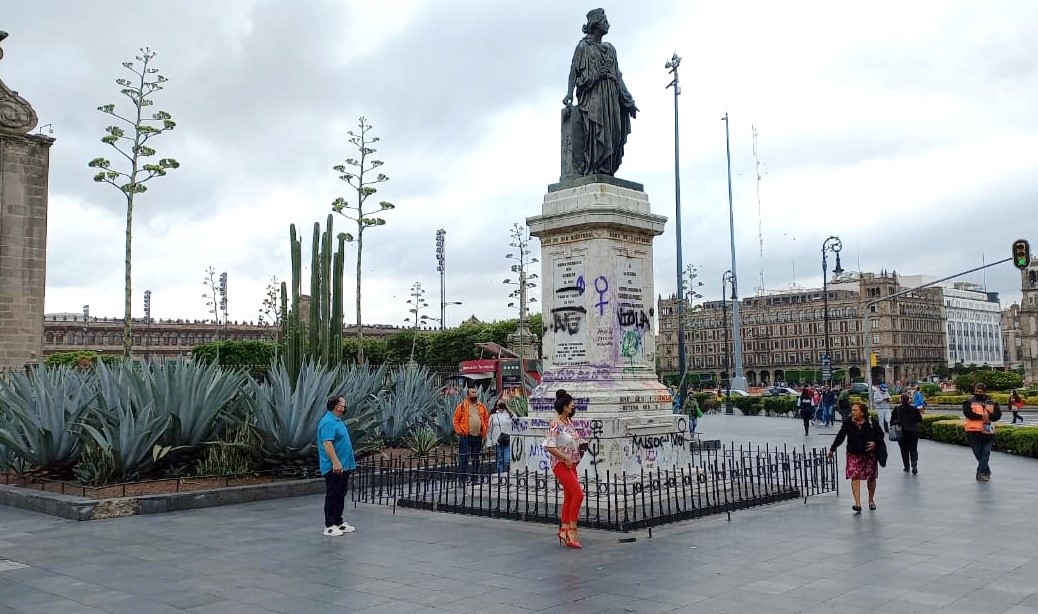
MexicoCity.cdmx.gob.mx

< Go Back

Hypsographic Monument to Enrico Martínez

hypsographic monument


Mexico City’s Hypsographic Monument appears to be a mere allegorical statue on one corner of the Metropolitan Cathedral. It’s the southernmost point of the Plaza del Marqués. In fact, the work is dedicated to Enrico Martínez, the Royal cosmographer, interpreter, publisher and early hydraulic engineer.

  • Enrico Martínez (ca. 1550-60 – 1632) was a mysterious historical figure. Alexander von Humboldt reported that he had been either German or Dutch, and many believe he was born in Hamburg, but this is still disputed.
  • In 1607, the Viceroy of New Spain Don Luis de Velasco, assigned him the task of draining the valley surrounding Mexico City, long subjected to devastating floods. Unfortunately, the tunnels Martínez had dug entirely collapsed. Controversy and inadequacy plagued the early project until finally in 1629 the City was entirely flooded for nearly five years. Some 30,000 people may have died. Martínez is remembered though for being among the earliest to attempt the colossal task.
  • The monument was designed by architect Francisco Jiménez to bear the sculpture created by Miguel Noreña. Noreña (1839-1894) was granted six-months leave from the San Carlos Academy (he was director of the Sculpture Department) to make the sculpture in Europe. In these pages, a best-known work of the same colloborative team is that of the Monument to Cuauhtémoc on the Paseo de la Reforma.
  • Here, the allegorical figure is The City of Mexico figuratively honoring Enrico Martínez by placing laurels on the small (upper) pillar bearing his name.
  • Hypsometry is the measurement of elevations and depths of features of the Earth’s surface relative to sea level.

Vicente Riva Palacio (1832–1896), the liberal newspaper publisher, began an initiative to erect the monument in 1877. It was complete by 1881 and placed at the other side of the front of the cathedral, near the beginning of today’s Moneda Street.  The statue was moved to its present location in 1925, although it was supposed to also indicate Mexico’s “Kilometer Zero,” a standard of measure for all cartographic undertakings at that time.

It’s referred to as the Hypsographic Monument, though, because the pedestal has indicators to show the average level of water on the lakes of Xochimilco, San Cristobal, Xaltocan and Zumpango. The pedestal also has other scientific standards, such as the measure of the meter, the yard, and the rod. It’s a very clear reminder of the 19th-century tendency to combine public art with scientific purpose.


How to get here
  • Calle Monte de Piedad 7, Centro Histórico, Cuauhtémoc, Centro, CDMX

Nearby

Catedral Metropolitana

Nearest at 0.09 kms.

El Balcón del Zócalo

Nearest at 0.1 kms.

Recomendado por CANIRAC

Mercaderes

Nearest at 0.1 kms.

Recomendado por CANIRAC

Related

Plaza del Seminario

Site of the rebirth of Modern Mexico from its ancient roots . . .

Gran Hotel de la Ciudad de México

A landmark hotel on the edge of Mexico City's main plaza . . .

Casa de la Primera Imprenta (Casa de las Campanas)

One of the Center City's most important cultural centers with a small fascinating museum...

Benito Juárez Museum, National Palace

A historical museum within Mexico's National Palace...

Plazuela del Marqués / Plaza Menor (Zócalo)

An important stop for Turibus and Capital Bus, it's more than just that...

Practical guide and services