Foto: Mitrush en Wikimedia Commons
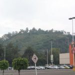
El Cerro del Chiquihuite es quizás el pico más célebre de la Sierra de Guadalupe. Constituye el límite entre esta parte de Gustavo A. Madero y el municipio de Tlalnepantla de Baz, en el Estado de México, al noreste. Con unos 2.700 metros, no es el más alto de la Sierra, pero la posición de los cerros lo convierte en uno de los más destacados.
Técnicamente es un domo volcánico de carácter exógeno. Pero para la mayoría de los habitantes de la Ciudad de México, es la montaña con las antenas que se ven cuando se conduce en línea recta hacia el norte por Insurgentes. Hoy en día se encuentra en una gran área natural protegida. Se puede acceder a ella desde la estación del Cablebús Tlalpexco, que está justo al norte de la cima. La caminata dura aproximadamente una hora.
El nombre náhuatl Tecpayocan se traduce como “lugar de pedernal”. Efectivamente, la montaña tiene una larga historia como proveedora de piedra de cantera. La andesita lamprobolita, una roca de tonos rosados a violáceos, se corta fácilmente en grandes losas. Fue muy apreciada y se utilizó ampliamente en la construcción del Templo Mayor.
En la ladera noreste del pico se encuentra el barrio de Lázaro Cárdenas, en Tlalnepantla (Estado de México). Suele citarse como el barrio más densamente poblado de todo el país. No son muchos los visitantes internacionales que hacen el viaje hasta la cima, aunque el Cablebús lo ha facilitado mucho. Las vistas, en un día claro, son espectaculares.

Cercano a 0.88 kms.

Cercano a 1.15 kms.

Cercano a 1.27 kms.

Una punta de la Sierra de Guadalupe confundida frecuentemente...

Una de las entradas más populares a la Sierra por el lado norte, totalmente pavimentada.

Un área enorme y difícil de picos montañosos en el extremo norte de la Ciudad de México.

Un nuevo complejo deportivo, recreativo y cultural en las alturas de Cuautepec...

Pico suroeste de la Sierra de Guadalupe...